


FIND IT FAST!
Hit Control F
Type your Keyword
Jump to the hike you're looking for Fast!

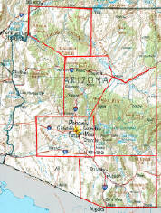
CHIRICAHUA'S ARIZONA
and Surrounding area
GO VIRTUAL HIKE THROUGH A SAMPLING OF WHAT SCENERY,
TERRAIN, VEGETATION, AND ADVENTURES ARE AVAILABLE
FOR HIKING, CAMPING, AND BACKPACKING IN THIS AREA.

BONITA CANYON - MARCH
ECHO CANYON - MARCH
ED RIGGS TRAIL - MARCH
HAILSTONE TRAIL - MARCH
HEART OF ROCKS - MARCH
HORSE TRAIL BY COCHISE HEAD - MARCH

INSPIRATION POINT - MARCH
LOWER RHYOLITE TRAIL - MARCH
NATURAL BRIDGE - MARCH
MASSAI POINT - MARCH
SARAH DEMING TRAIL - MARCH
TRAIL AREAS DOCUMENTED ON THIS PAGE
IF YOU EXPERIENCE VIEWING PROBLEMS - disable your pop-up blocker -
CLEAR YOUR INTERNET COOKIES/TEMP FILES - THEN REFRESH YOUR BROWSER
*initial blurry photos should resize to your system within a few seconds*
FOR A LARGER PICTURE VIEW - START THE SLIDESHOW AND CLICK A SLIDESHOW PHOTO - THEN SELECT THE
"FULL SCREEN" OPTION TO YOUR UPPER LEFT OF THAT SCREEN - HIT F11 AND YOU CAN CONTROL THE SPEED

HIKING - BACKPACKING - CAMPING - SNORKELING - SCUBA - KAYAK -TRAVEL
All text, graphics and images are original - Copyright © 2003-2010 by Nunya
Please refrain from using any content without the written consent of the author at
NatureWildChild@gmail.com

This Hike by members of Arizona Outdoor Travel Club of Phoenix Arizona
- view their hiking calendars

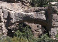
03/30/2008 Natural Bridge - Coronado National Forest -
Chiricahua National Monument Arizona
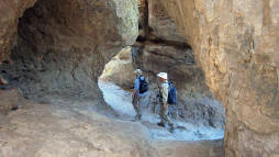
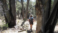
The Natural Bridge in the Chiricahua National Monument spans over 30ft, and is located in Bonita Canyon. Go Virtual Hike with us 4.8 miles (round-trip) starting at 5560ft elevation, with a steady increase up to 5980ft within the first mile, and then continuing on a rolling up and down trail through the Apache Pines of Picket Park (5818ft elevation), for a view of this
stone archway. (photos by Nunya)

This Hike by members of Arizona Outdoor Travel Club of Phoenix Arizona
- view their hiking calendars
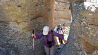
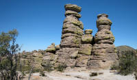
03/30/2008 Massai Point - to Ed Riggs Trail - to Hailstone Trail - to Echo Canyon Coronado National Forest -
Chiricahua National Monument Arizona
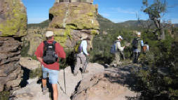
The Echo Canyon Loop is every bit as impressive as the Heart of Rocks Loop - and a Must-See at Chiricahua National Monument! Go Virtual Hike with us as we once again start at Massai point (6870ft elevation) to Ed Riggs Trail, but this time take you down Hailstone Trail to beautiful Echo Canyon (6330ft elevation) to play amongst the volcanic spiraling pinnacles of standing rock.
(photos by Nunya)
This Hike by members of Arizona Outdoor Travel Club of Phoenix Arizona
- view their hiking calendars


This Hike by members of Arizona Outdoor Travel Club of Phoenix Arizona
- view their hiking calendars
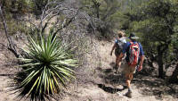
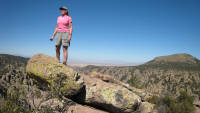
03/29/2008 Massai Point - to Ed Riggs Trail -
to Inspiration Point - to Heart of Rocks - to Sarah Deming Trail - to Lower Rhyolite Trail - Coronado National Forest - -
Chiricahua National Monument Arizona
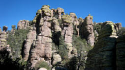
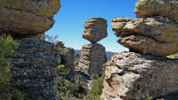
The Chiricahua Apache Indians called the spiral, pinnacle shaped rock formations "standing up rocks", which were formed 27 million years ago with eruptions when Turkey Creek Volcano spewed ash over 1200 square miles. Go Virtual Hike with us 8.8+ miles through this amazing display as we start from Massai Point, to Ed Riggs Trail, out to Inspiration Point, around the Heart of Rocks, and down the Sarah Deming Trail to the Lower Rhyolite Canyon in the Chiricahua National Monument of Arizona.
(photos by Nunya)
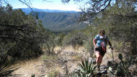
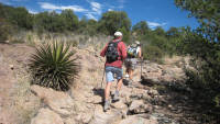
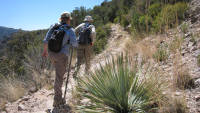
03/28/2008 Horse Trail by Cochise Head - to Indian Creek -
Coronado National Forest -
Chiricahua National Monument Arizona
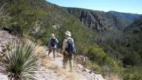
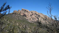
Cochise Head, in the Chiricahua National Monument of SouthEastern Arizona - starts out our tour of a truly amazing area known as a "sky island" which supports 4 ecosystems, with spiraling pinnacle rocks reminiscent of the rock Hoodoos found in Bryce Canyon Utah. Go Virtual Hike with us as we warm up with an 8 mile stroll of Horse trail to Indian Creek, which doesn't even elude to the *wow* yet to come. (photos by Nunya)
Commercial - Residential
General Contractor
AzUSA - Builders.com

GoVirtualHike.com
Virtual Hiking
RESEARCH HIKES
VIRTUAL TRAVEL
VACATION GETAWAYS

Virtual Hiking
RESEARCH HIKES
VIRTUAL TRAVEL
VACATION GETAWAYS
GoVirtualHike.com
Virtual Hiking
OVER 300
HIKES FOR
ARIZONA
CALIFORNIA
COLORADO
HAWAII
KAUA'I
NEW MEXICO
OREGON
ST MAARTEN
UTAH
OVER 300
HIKES FOR
ARIZONA
CALIFORNIA
COLORADO
HAWAII
KAUA'I
NEW MEXICO
OREGON
ST MAARTEN
UTAH