


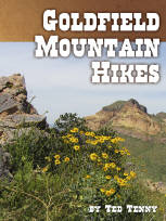
All text, graphics and images are original - Copyright © 2003-2009 by Nunya
Please refrain from using any content without the written consent of the author at
NatureWildChild@gmail.com
HIKING - BACKPACKING - CAMPING - SNORKELING - SCUBA - KAYAK -TRAVEL


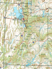
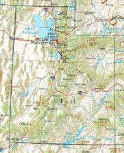
MOAB UTAH
and surrounding area
GO VIRTUAL HIKE THROUGH A SAMPLING OF WHAT SCENERY,
TERRAIN, VEGETATION, AND ADVENTURES ARE AVAILABLE
FOR HIKING, CAMPING, AND BACKPACKING IN THIS AREA.
TRAIL AREAS DOCUMENTED ON THIS PAGE
FIND IT FAST!
Hit Control F
Type your Keyword
Jump to the hike you're looking for Fast!
IF YOU EXPERIENCE VIEWING PROBLEMS - disable your pop-up blocker -
CLEAR YOUR INTERNET COOKIES/TEMP FILES - THEN REFRESH YOUR BROWSER
*initial blurry photos should resize to your system within a few seconds*


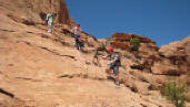

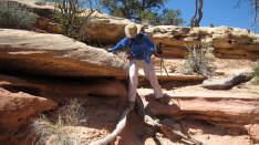
04/18/2008 Corona Arch - "Little Rainbow Bridge" and
Bowtie Arch - Bootlegger Canyon - Canyonlands - Moab Utah
Corona Arch in Moab Utah, is pretty impressive on it's own, but even more so to fathom that Moab native Tim Martin (born 1940) actually flew his private plane through the 140ft by 105ft opening in the 1980's, before current Federal regulations were in place! Go Virtual Hike with us 1.5 miles (3 miles round-trip) across a 440ft elevation climb up beautiful red slickrock, to view this magnificent Arch (also known as Little Rainbow Bridge) and the equally impressive Bowtie Arch. (photos by Nunya)


04/14/2008 Devil's Garden Trail - Primitive Loop Trail -
Arches National Park - Moab Utah
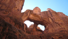


04/14/2008 Fiery Furnace - Arches National Park - Moab Utah
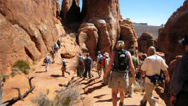
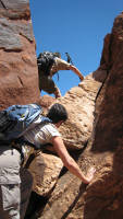
Hiking the Fiery Furnace in the Arches National Park of Moab Utah... *warns* of the dangers of easily becoming lost or injured in this area - a true statement for sure. However... Go Virtual Hike with us 2.5 miles through this Ranger-led labyrinth maze of dead-end canyons, rock scrambles, and slot canyon squeezes - filled with natural arches, bridges, and nothing but FUN! (photos by Nunya)


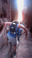
04/15/2008 Murphy Trail to White Rim Rd via Hogback -
Island in the Sky - Canyonlands - Moab Utah
The weather report warned of high winds exceeding 45 mph... and they weren't wrong! Go Virtual Hike with us down a horseshoe shaped cliff that I dubbed The Devil's Whirlpool - as we got blasted with sand, and flung against rocks while climbing back out... but hey, it was pretty! (photos by Nunya)


04/16/2008 Neck Springs Loop - Island in the Sky - Canyonlands - Moab Utah

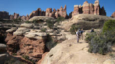


04/17/2008 Elephant Hill - Chesler Park - The Joint - Needles District - Canyonlands - Moab Utah


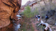


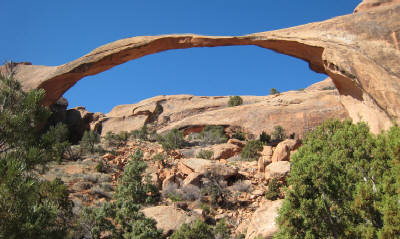
04/18/2008 Negro Bill Canyon to Morning Glory Bridge -
La Sal Mountain area - Canyonlands - Moab Utah
Negro Bill Canyon is located in the La Sal Mountain Canyonlands area around Moab Utah, and is a refreshing change with trees and multiple stream crossings. Go Virtual Hike with us on the 4 mile (in-and-out) 330ft elevation gain hike to Morning Glory Bridge - at 243ft across, it is the sixth largest rock span in the United States. (photos by Nunya)

BOWTIE ARCH
BOOTLEGGERS CANYON
CANYONLANDS
CHESLER PARK
CORONA ARCH "Little Rainbow Bridge"
DEVIL'S GARDEN TRAIL
ELEPHANT HILL
FIERY FURNACE
HOGBACK
LA SAL MOUNTAIN
MORNING GLORY BRIDGE
MURPHY TRAIL
NECK SPRINGS LOOP
NEEDLES DISTRICT
NEGRO BILL CANYON
PRIMITIVE LOOP TRAIL
THE JOINT
WHITE RIM ROAD
Virtual Hiking
HIKING
CAMPING
BACKPACKING
GoVirtualHike.com
GoVirtualHike.com
GoVirtualHike.com
HIKING
CAMPING
BACKPACKING
HIKING
CAMPING
BACKPACKING
Over 300
Virtual Hikes
for
HIKING
CAMPING
BACKPACKING
Over 300
Virtual Hikes
for
ARIZONA
CALIFORNIA
COLORADO
HAWAII
KAUA'I
NEW MEXICO
OREGON
ST MAARTEN
UTAH


FOR A LARGER VIEW
CLICK ON THE
BIGGER PHOTO
THEN SELECT
THE "FULL SCREEN"
OPTION TO YOUR
UPPER LEFT - HIT F11
AND YOU CAN
CONTROL THE SPEED


04/13/2008 SYNCLINE LOOP TRAIL - ISLAND IN THE SKY
CANYONLANDS - MOAB UTAH
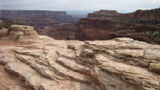
Canyonlands National Park - located 35 miles West of Moab, is the largest National Park in Utah, and is divided into 3 areas know as Island in the Sky, the Needles, and the Maze. Go Virtual Hike with us 8.3 miles (1300ft elevation change) on the strenuous, rock scrambling Syncline Loop Trail, located in the Island in the Sky district of Canyonlands National Park. (photos by Nunya)
I AM AWARE THAT KODAK HAS MADE CHANGES TO THEIR SOFTWARE - THAT NOW SCREW UP YOUR VIEWING THOSE SLIDESHOWS - I'LL FIX THOSE AS SOON AS I CAN *SORRY*
I AM AWARE THAT KODAK HAS MADE CHANGES TO THEIR SOFTWARE - THAT NOW SCREW UP YOUR VIEWING THOSE SLIDESHOWS - I'LL FIX THOSE AS SOON AS I CAN *SORRY*
I AM AWARE THAT KODAK HAS MADE CHANGES TO THEIR SOFTWARE - THAT NOW SCREW UP YOUR VIEWING THOSE SLIDESHOWS - I'LL FIX THOSE AS SOON AS I CAN *SORRY*
I AM AWARE THAT KODAK HAS MADE CHANGES TO THEIR SOFTWARE - THAT NOW SCREW UP YOUR VIEWING THOSE SLIDESHOWS - I'LL FIX THOSE AS SOON AS I CAN *SORRY*