


All text, graphics and images are original - Copyright © 2003-2009 by Nunya
Please refrain from using any content without the written consent of the author at
NatureWildChild@gmail.com
HIKING - BACKPACKING - CAMPING - SNORKELING - SCUBA - KAYAK -TRAVEL


SAN JACINTO MOUNTAINS CALIFORNIA
And Surrounding Area
GO VIRTUAL HIKE THROUGH A SAMPLING OF WHAT SCENERY,
TERRAIN, VEGETATION, AND ADVENTURES ARE AVAILABLE
FOR HIKING, CAMPING, AND BACKPACKING IN THIS AREA.
TRAIL AREAS DOCUMENTED ON THIS PAGE
FIND IT FAST!
Hit Control F
Type your Keyword
Jump to the hike you're looking for Fast!
IF YOU EXPERIENCE VIEWING PROBLEMS - disable your pop-up blocker -
CLEAR YOUR INTERNET COOKIES/TEMP FILES - THEN REFRESH YOUR BROWSER
*initial blurry photos should resize to your system within a few seconds*
CACTUS TO CLOUDS - MAY
DEVIL'S SLIDE TRAIL - JULY
LONG VALLEY TRAIL - MAY
ROUND VALLEY - MAY
SAN JACINTO PEAK - JULY
JOSHUA TREE - OCTOBER
HOUSE IN THE ROCK - SOUTH END
MT CENTER - OCTOBER
PACIFIC COAST TRAIL


05/21/2006 Long Valley to Round Valley - San Jacinto -
Palm Springs California
Long Valley is located at the Tram area of San Jacinto, going up from Palm Springs CA. Go Virtual Hike with us in the pine scented air (30 degrees cooler than Palm Springs), starting at 8516ft to 9100ft elevation on a 6+ mile stroll through Long Valley, to Round Valley, Tamarak Valley and back.
(photos by Nunya)


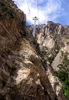
05/20/2006 Cactus to Clouds - San Jacinto - Palm Springs California
Imagine a hike where you have an elevation gain of 1000ft every mile. Now repeat it - 8 more times! Go Virtual Hike with us to "Cactus to Clouds" as we start in Palm Springs CA & take you up 8116ft elevation gain in 8.5 miles to the Tram station between you & the 5.5 miles to San Jacinto Peak. Hang on for the ride as we glide you back down 8516ft in the World's Largest Rotating Tramcar. (photos by Nunya)


10/29/2005 Pacific Crest Trail - Mt Center area California
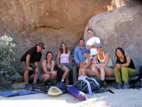
26 Sierra San Gorgonio members hiked with me on my last group hike from my stay in California. 11 miles on the Pacific Coast Trail near Mountain Center (by Idyllwild), with an easy 800ft elevation change. Weather was cool, views for miles, and the company was great. (photos by Nunya)


10/01/2005 Joshua Tree to House in the Rock -
South End of Joshua Tree National Park - Twentynine Palms California


07/30/2005 Devil's Slide Trail to San Jacinto Peak via Idyllwilld California
Over 300
Virtual Hikes
for
HIKING
CAMPING
BACKPACKING
Over 300
Virtual Hikes
for
HIKING
CAMPING
BACKPACKING

I AM AWARE THAT KODAK HAS MADE CHANGES TO THEIR SOFTWARE - THAT NOW SCREW UP YOUR VIEWING THOSE SLIDESHOWS - I'LL FIX THOSE AS SOON AS I CAN *SORRY*
I AM AWARE THAT KODAK HAS MADE CHANGES TO THEIR SOFTWARE - THAT NOW SCREW UP YOUR VIEWING THOSE SLIDESHOWS - I'LL FIX THOSE AS SOON AS I CAN *SORRY*
I AM AWARE THAT KODAK HAS MADE CHANGES TO THEIR SOFTWARE - THAT NOW SCREW UP YOUR VIEWING THOSE SLIDESHOWS - I'LL FIX THOSE AS SOON AS I CAN *SORRY*