


Trail Areas Documented on This Page
GO VIRTUAL HIKE THROUGH A SAMPLING OF WHAT SCENERY,
TERRAIN, VEGETATION, AND ADVENTURES ARE AVAILABLE
FOR HIKING, CAMPING, AND BACKPACKING IN THIS AREA.
IF YOU EXPERIENCE VIEWING PROBLEMS - disable your pop-up blocker -
CLEAR YOUR INTERNET COOKIES/TEMP FILES - THEN REFRESH YOUR BROWSER
*initial blurry photos should resize to your system within a few seconds*
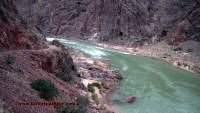
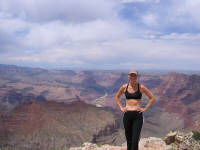
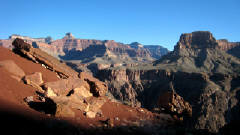
05/27/2005 - 05/28/2005 Bright Angel to Plateau Point - South Rim Grand Canyon Arizona
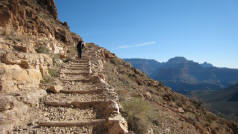
06/17/2006 South Kaibab to Phantom Ranch - up Bright Angel -
South Rim Grand Canyon Arizona
After hiking 100 miles in 9 days, let me breeze you down another 17 miles in the Grand Canyon! Go Virtual Hike down South Kaibab starting at 7260ft elevation to Phantom Ranch (at 2400ft elevation), and back up Bright Angel (6900ft elevation). Spectacular views, snakes, lizards and deer - and the photo of the three crazy hikers that finished this trek. (photos by Nunya)
11/25/2006 SOUTH KAIBAB TO PHANTOM RANCH - UP BRIGHT ANGEL -
SOUTH RIM GRAND CANYON
Hiking the Grand Canyon after dark?!?... many people do! It's certainly one way to capture a beautiful sunset, as well as make for a very interesting hike! Go Virtual Hike with us as we get a late start down South Kaibab (7260ft el), and take you down 4860ft in 6.3 miles across the Colorado River to Phantom Ranch, and then up 4500ft on the Bright Angel trail - with the last 3 miles in total darkness! 18 miles round trip (photos by Nunya)
12/10/2006 BRIGHT ANGEL - TO TONTO PLATEAU - TO SOUTH KAIBAB -
TO PHANTOM RANCH - SOUTH RIM GRAND CANYON ARIZONA
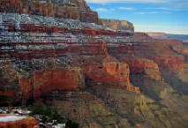
Imagine watching the storm front ahead of you, only to be hit by surprise from behind by another one. The results (besides a wet rump) - Stunning photographs of a rain drenched Grand Canyon covered in a glaze of ice and snow capped tops. Go Virtual Hike with us as we take you over 4.6+ miles down Bright Angel (6900ft elevation), across the floor of the Tonto Plateau (4.4+ miles, 3800ft el), and down South Kaibab another 2.8+ miles to Phantom Ranch (2400ft elevation). Rain, snow, sleet, warm sunshine and Anasazi Indian ruins - all in one hike!
(photos by Nunya)
12/12/2006 Phantom Ranch - up South Kaibab - South Rim Grand Canyon Arizona
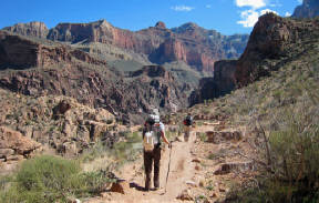
South Kaibab is one of the most famously photographed areas of the Grand Canyon. Go Virtual Hike with us 7.1 miles, as we start you in the dark from Phantom Ranch, take you across the Colorado river - and up 4860ft with beautiful Sunrise views on the South Kaibab trail. (photos by Nunya)
03/17/2007 Phantom Ranch via South Kaibab - South Rim Grand Canyon Arizona
Getting to Phantom Ranch going down South Kaibab of the Grand Canyon is my favorite route! Go Virtual Hike with us down over 4860ft in 7.1 miles - across the Colorado River to the heartbeat of the Grand Canyon known as Phantom Ranch. (photos by Nunya)
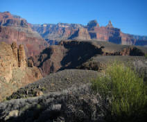
03/18/2007 Clear Creek Trail - Grand Canyon Arizona
Less than a mile from Phantom Ranch, is the Clear Creek Trailhead heading East across the Tonto Plateau. Go Virtual Hike with us as we take you intimately close to the majestic carved rocks and crevasses, that you can only gaze at in wonderment when you stand on the rim of the Grand Canyon! (photos by Nunya)
03/19/2007 Phantom Ranch - up Bright Angel - South Rim Grand Canyon Arizona
Spring in the Grand Canyon splashes a whole new array of colors to this beautiful "hole in the ground". Go Virtual Hike with us 9.6 miles from Phantom Ranch (2446ft elevation) up Bright Angel trail (6900ft elevation), through waterfalls, canyon creatures, a cave, and a chat with Maverick - all on the most popular trail in the Grand Canyon! (photos by Nunya)
12/15/2007 South Kaibab to Phantom Ranch - South Rim Grand Canyon Arizona
12/16/2007 Phantom Ranch - up Bright Angel - across Tonto Plateau - down South Kaibab to Phantom Ranch - South Rim Grand Canyon Arizona
12/17/2007 Phantom Ranch - up South Kaibab - South Rim Grand Canyon Arizona
03/08/2008 Phantom Ranch via Bright Angel - Grand Canyon Arizona
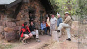
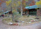
Usually.... I stick to documenting "just the trails" - but not this time! Go Virtual Hike with us 9.6 miles down Bright Angel trail (6900ft elevation) to Phantom Ranch (2400ft elevation) - sliding 2 1/2 miles down icy trail into the stunning beauty of the Grand Canyon - but THIS time... to a few of the secrets of Phantom Ranch, and the man responsible for many of us having the privilege of feeling we are coming home. (photos by Nunya)
03/09/2008 Phantom Ranch - to Ribbon Falls - to Cottonwood -
to the Pump House Bridge - and Back ! - Grand Canyon Arizona
Can it get any better than this? - Absolutely! Go Virtual Hike with us from Phantom Ranch as we show you the avalanche damaged 3rd bridge to Ribbon Falls, and the major efforts the trail maintenance crew puts forth to keep the trails passable all the way through Cottonwood to the Pump Station Bridge and back! (photos by Nunya)

03/10/2008 South Kaibab via Phantom Ranch - Grand Canyon Arizona
Just when you thought you couldn't be shown anything new... the adventure begins all over again! Go Virtual Hike with us from Phantom Ranch, up South Kaibab. View the changes along the Colorado River from the recent Glen Canyon Dam water-release experiment, and the stunning views as you climb 4,860ft up to the ice covered South Rim of the Grand Canyon. (photos by Nunya)


12/15/2008 Phantom Ranch up Bright Angel Trail -
South Rim Grand Canyon Arizona
There is much in the World that is negative, so let me show you what is not.
Go Virtual Hike with us 9.6 miles from Phantom Ranch in the Grand Canyon of Arizona, and up Bright Angel trail to the South Rim - into a New Year of adventure, and finding simple beauty and often amazement, in what is right in front of you - through my eyes. (photos by Nunya)


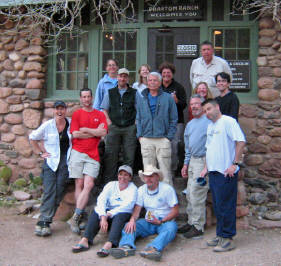
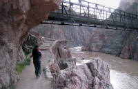
12/14/2008 Grand Canyon Corridor - Phantom Ranch Arizona
There are 5 bridges lacing through the Grand Canyon Corridor between Phantom Ranch and Ribbon Falls, an area prone to rock avalanches and flash flood action. Go Virtual Hike with us through the splendor of this Rim-to-Rim section, see more views of what Phantom Ranch looks like, catch that Group Photo - and the Surprise Tribute that you couldn't hope
to even guess ahead of time! (photos by Nunya)


12/13/2008 South Kaibab to Phantom Ranch - Grand Canyon Arizona
Go Virtual Hike with us 7.1 miles, descending over 4,860ft from South Kaibab to Phantom Ranch, in the fierce wind of an approching snowstorm! Excitement, Beauty and Brutality - The Grand Canyon of Arizona never fails to deliver Adventure! (photos by Nunya)
SOUTH RIM GRAND CANYON
Arizona
South Rim to Phantom ranch
DOWN SOUTH KAIBAB TO PHANTOM - MARCH
DOWN SOUTH KAIBAB - TO PHANTOM RANCH - UP BRIGHT ANGEL - JUNE
DOWN SOUTH KAIBAB - TO PHANTOM RANCH - UP BRIGHT ANGEL - NOVEMBER
DOWN SOUTH KAIBAB TO PHANTOM RANCH - DECEMBER
DOWN BRIGHT ANGEL TO PHANTOM RANCH - MARCH
DOWN BRIGHT ANGEL TO PLATEAU POINT AND BACK - MAY
DOWN BRIGHT ANGEL - ACROSS TONTO PLATEAU - DOWN SOUTH KAIBAB - TO PHANTOM RANCH - DECEMBER
GRAND CANYON CORRIDOR - PHANTOM RANCH - DECEMBER
UP BRIGHT ANGEL FROM PHANTOM RANCH - MARCH
UP BRIGHT ANGEL FROM PHANTOM RANCH - DECEMBER
UP SOUTH KAIBAB FROM PHANTOM RANCH - MARCH
UP SOUTH KAIBAB FROM PHANTOM RANCH - DECEMBER
PHANTOM RANCH - TO CLEAR CREEK AND BACK - MARCH
PHANTOM RANCH - TO RIBBON FALLS - TO COTTONWOOD - TO PUMP HOUSE BRIDGE AND BACK - MARCH
PHANTOM RANCH - UP BRIGHT ANGEL - ACROSS TONTO PLATEAU - DOWN SOUTH KAIBAB TO PHANTOM RANCH - DECEMBER
FIND IT FAST!
Hit Control F
Type your Keyword
Jump to the hike you're looking for Fast!

Over 300
Virtual Hikes
for
HIKING
CAMPING
BACKPACKING
Over 300
Virtual Hikes
for
HIKING
CAMPING
BACKPACKING


HIKING
CAMPING
BACKPACKING
GoVirtualHike.com

GoVirtualHike.com

GoVirtualHike.com
Over 300
Virtual Hikes
for
ARIZONA
CALIFORNIA
COLORADO
HAWAII
KAUA'I
NEW MEXICO
OREGON
ST MAARTEN
UTAH
GoVirtualHike.com
Virtual Hiking
HIKING
CAMPING
BACKPACKING
GoVirtualHike.com
RESEARCH HIKES
VIRTUAL TRAVEL
VACATION GETAWAYS
Over 300
Virtual Hikes
for
ARIZONA
CALIFORNIA
COLORADO
HAWAII
KAUA'I
NEW MEXICO
OREGON
ST MAARTEN
UTAH
Virtual Hiking
GoVirtualHike.com
HIKING
CAMPING
BACKPACKING
GoVirtualHike.com
RESEARCH HIKES
VIRTUAL TRAVEL
VACATION GETAWAYS
GoVirtualHike.com
Virtual Hiking
Over 300
Virtual Hikes
for
ARIZONA
CALIFORNIA
COLORADO
HAWAII
KAUA'I
NEW MEXICO
OREGON
ST MAARTEN
UTAH
GoVirtualHike.com
HIKING
CAMPING
BACKPACKING
Virtual Hiking
GoVirtualHike.com
RESEARCH HIKES
VIRTUAL TRAVEL
VACATION GETAWAYS
GoVirtualHike.com
Over 300
Virtual Hikes
for
ARIZONA
CALIFORNIA
COLORADO
HAWAII
KAUA'I
NEW MEXICO
OREGON
ST MAARTEN
UTAH
Virtual Hiking
GoVirtualHike.com
HIKING
CAMPING
BACKPACKING
GoVirtualHike.com
RESEARCH HIKES
VIRTUAL TRAVEL
VACATION GETAWAYS
GoVirtualHike.com
Virtual Hiking
Over 300
Virtual Hikes
for
ARIZONA
CALIFORNIA
COLORADO
HAWAII
KAUA'I
NEW MEXICO
OREGON
ST MAARTEN
UTAH
GoVirtualHike.com
HIKING
CAMPING
BACKPACKING
GoVirtualHike.com
RESEARCH HIKES
VIRTUAL TRAVEL
VACATION GETAWAYS
Virtual Hiking
Over 300
Virtual Hikes
for
ARIZONA
CALIFORNIA
COLORADO
HAWAII
KAUA'I
NEW MEXICO
OREGON
ST MAARTEN
UTAH
GoVirtualHike.com
Virtual Hiking
HIKING
CAMPING
BACKPACKING
GoVirtualHike.com
RESEARCH HIKES
VIRTUAL TRAVEL
VACATION GETAWAYS
GoVirtualHike.com
Over 300
Virtual Hikes
for
ARIZONA
CALIFORNIA
COLORADO
HAWAII
KAUA'I
NEW MEXICO
OREGON
ST MAARTEN
UTAH
GoVirtualHike.com
HIKING
CAMPING
BACKPACKING
GoVirtualHike.com
RESEARCH HIKES
VIRTUAL TRAVEL
VACATION GETAWAYS
Over 300
Virtual Hikes
for
ARIZONA
CALIFORNIA
COLORADO
HAWAII
KAUA'I
NEW MEXICO
OREGON
ST MAARTEN
UTAH
HIKING
CAMPING
BACKPACKING
GoVirtualHike.com
RESEARCH HIKES
VIRTUAL TRAVEL
VACATION GETAWAYS


HIKING - BACKPACKING - CAMPING - SNORKELING - SCUBA - KAYAK -TRAVEL
All text, graphics and images are original - Copyright © 2003-2009 by Nunya
Please refrain from using any content without the written consent of the author at
NatureWildChild@gmail.com
FOR A LARGER PICTURE VIEW - START THE SLIDESHOW AND CLICK A SLIDESHOW PHOTO - THEN SELECT THE
"FULL SCREEN" OPTION TO YOUR UPPER LEFT OF THAT SCREEN - HIT F11 AND YOU CAN CONTROL THE SPEED


I AM AWARE THAT KODAK HAS MADE CHANGES TO THEIR SOFTWARE - THAT NOW SCREW UP YOUR VIEWING THOSE SLIDESHOWS - I'LL FIX THOSE AS SOON AS I CAN *SORRY*
I AM AWARE THAT KODAK HAS MADE CHANGES TO THEIR SOFTWARE - THAT NOW SCREW UP YOUR VIEWING THOSE SLIDESHOWS - I'LL FIX THOSE AS SOON AS I CAN *SORRY*
I AM AWARE THAT KODAK HAS MADE CHANGES TO THEIR SOFTWARE - THAT NOW SCREW UP YOUR VIEWING THOSE SLIDESHOWS - I'LL FIX THOSE AS SOON AS I CAN *SORRY*
I AM AWARE THAT KODAK HAS MADE CHANGES TO THEIR SOFTWARE - THAT NOW SCREW UP YOUR VIEWING THOSE SLIDESHOWS - I'LL FIX THOSE AS SOON AS I CAN *SORRY*
I AM AWARE THAT KODAK HAS MADE CHANGES TO THEIR SOFTWARE - THAT NOW SCREW UP YOUR VIEWING THOSE SLIDESHOWS - I'LL FIX THOSE AS SOON AS I CAN *SORRY*
I AM AWARE THAT KODAK HAS MADE CHANGES TO THEIR SOFTWARE - THAT NOW SCREW UP YOUR VIEWING THOSE SLIDESHOWS - I'LL FIX THOSE AS SOON AS I CAN *SORRY*

