


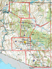
NAVAJO COUNTY ARIZONA
and Surrounding Area
GO VIRTUAL HIKE THROUGH A SAMPLING OF WHAT SCENERY,
TERRAIN, VEGETATION, AND ADVENTURES ARE AVAILABLE
FOR HIKING, CAMPING, AND BACKPACKING IN THIS AREA.
TRAIL AREAS DOCUMENTED ON THIS PAGE
FIND IT FAST!
Hit Control F
Type your Keyword
Jump to the hike you're looking for Fast!
IF YOU EXPERIENCE VIEWING PROBLEMS - disable your pop-up blocker -
CLEAR YOUR INTERNET COOKIES/TEMP FILES - THEN REFRESH YOUR BROWSER
*initial blurry photos should resize to your system within a few seconds*

KEET SEEL - HIKE IN - MAY
KEET SEEL - INDIAN RUINS - MAY
KEET SEEL - HIKE OUT - MAY
SANDAL TRAIL - MAY


05/26/2007 Sandal Trail and Aspen Trail -
Navajo County Arizona
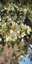
Sandal Trail and Aspen Forest Trail, located at the top of the Keet Seel area on the Navajo County Indian Reservation in the NorthEast corner of Arizona, is a walk through history for non-hikers and hikers alike. Go Virtual Hike with us on this tourist friendly, semi-handicap accessible treasure - and put your foot beside a Dinosaur foot imprint that lived 180 million years ago! Learn the Navajo and Hopi Indian terms for (and see) what plants they used for everything from building materials, to food, medicine, and diaper pads! (photos by Nunya)


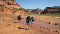


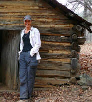
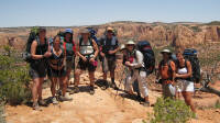
05/27/2007 Keet Seel - Hike In - Navajo County Arizona
Keet Seel is the largest, most well preserved 13-century Anasazi Indian Ruins in Arizona. Go Virtual Hike with us as we take you down 6.5 miles (17 round trip from the Visitor Center), into the beautiful red rock canyon stream, through quicksand - and charging "wild" animals! (photos by Nunya)


05/27/2007 Keet Seel - The Ruins - Navajo County Arizona
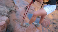
The hike into the Keet Seel Indian Ruins and back out - is 17 miles (round trip) from the Visitor Center, but from the Keet Seel campground - it's a splash through the creek and a short stroll over to the other side of the canyon. Go Virtual Hike with us as we splash you across that creek, and take you up into the Keet Seel Indian Ruin - once home to over a hundred 13-Century Anasazi Indians, and the largest and best-preserved, cliff-dwelling Ruins in the State of Arizona! (photos by Nunya)


05/28/2007 Keet Seel - Hike Out - Navajo County Arizona
When people that have done Keet Seel talk - they tell you about how hard the hike out is. Go Virtual Hike with us as we hike you through quicksand - and show you why that hike out gets such mention. (photos by Nunya)
All text, graphics and images are original - Copyright © 2003-2009 by Nunya
Please refrain from using any content without the written consent of the author at
NatureWildChild@gmail.com
HIKING - BACKPACKING - CAMPING - SNORKELING - SCUBA - KAYAK -TRAVEL

RESEARCH HIKES
VIRTUAL TRAVEL
VACATION GETAWAYS
RESEARCH HIKES
VIRTUAL TRAVEL
VACATION GETAWAYS
GoVirtualHike.com
I AM AWARE THAT KODAK HAS MADE CHANGES TO THEIR SOFTWARE - THAT NOW SCREW UP YOUR VIEWING THOSE SLIDESHOWS - I'LL FIX THOSE AS SOON AS I CAN *SORRY*
I AM AWARE THAT KODAK HAS MADE CHANGES TO THEIR SOFTWARE - THAT NOW SCREW UP YOUR VIEWING THOSE SLIDESHOWS - I'LL FIX THOSE AS SOON AS I CAN *SORRY*
I AM AWARE THAT KODAK HAS MADE CHANGES TO THEIR SOFTWARE - THAT NOW SCREW UP YOUR VIEWING THOSE SLIDESHOWS - I'LL FIX THOSE AS SOON AS I CAN *SORRY*
I AM AWARE THAT KODAK HAS MADE CHANGES TO THEIR SOFTWARE - THAT NOW SCREW UP YOUR VIEWING THOSE SLIDESHOWS - I'LL FIX THOSE AS SOON AS I CAN *SORRY*