


All text, graphics and images are original - Copyright © 2003-2009 by Nunya
Please refrain from using any content without the written consent of the author at
NatureWildChild@gmail.com


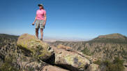

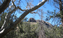


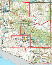


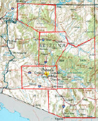


CHIRICAHUA NATIONAL MONUMENT ARIZONA
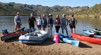
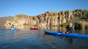
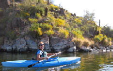
KAYAKING SAGUARO LAKE ARIZONA
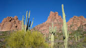
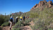
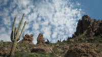
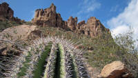
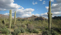
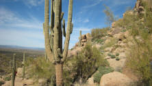
SUPERSTITION MOUNTAINS ARIZONA
GRAND CANYON ARIZONA
MAZATZAL MOUNTAINS ARIZONA
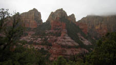
SEDONA ARIZONA
SCOTTSDALE ARIZONA
MCDOWELL MOUNTAINS ARIZONA
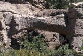
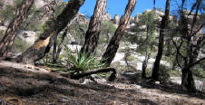
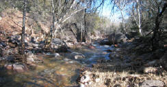
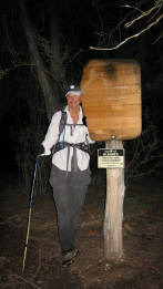
03/30/2008 Natural Bridge - Coronado National Forest -
Chiricahua Wilderness - Chiricahua National Monument Arizona
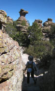
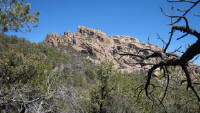
The Natural Bridge in the Chiricahua National Monument spans over 30ft, and is located in Bonita Canyon. Go Virtual Hike with us 4.8 miles (round-trip) starting at 5560ft elevation, with a steady increase up to 5980ft within the first mile, and then continuing on a rolling up and down trail through the Apache Pines of Picket Park (5818ft elevation), for a view of this stone archway. (photos by Nunya)
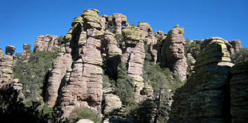
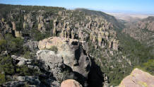
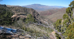
03/30/2008 Massai Point - to Ed Riggs Trail - to Hailstone Trail - to Echo Canyon Coronado National Forest - Chiricahua Wilderness -
Chiricahua National Monument Arizona
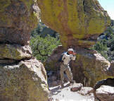
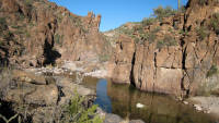
The Echo Canyon Loop is every bit as impressive as the Heart of Rocks Loop - and a Must-See at Chiricahua National Monument! Go Virtual Hike with us as we once again start at Massai point (6870ft elevation) to Ed Riggs Trail, but this time take you down Hailstone Trail to beautiful Echo Canyon (6330ft elevation) to play amongst the volcanic spiraling pinnacles of standing rock.
(photos by Nunya)
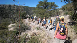
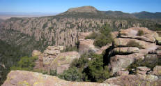
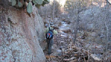
03/29/2008 Massai Point - to Ed Riggs Trail - to Inspiration Point -
to Heart of Rocks - to Sarah Deming Trail - to Lower Rhyolite Trail -
Coronado National Forest - Chiricahua Wilderness -
Chiricahua National Monument Arizona
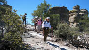
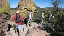
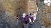
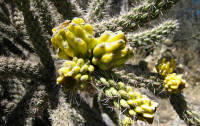
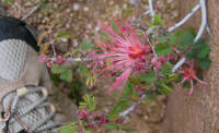
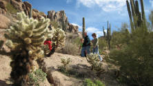
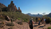
The Chiricahua Apache Indians called the spiral, pinnacle shaped rock formations "standing up rocks", which were formed 27 million years ago with eruptions when Turkey Creek Volcano spewed ash over 1200 square miles. Go Virtual Hike with us 8.8+ miles through this amazing display as we start from Massai Point, to Ed Riggs Trail, out to Inspiration Point, around the Heart of Rocks, and down the Sarah Deming Trail to the Lower Rhyolite Canyon in the Chiricahua National Monument of Arizona. (photos by Nunya)
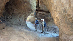
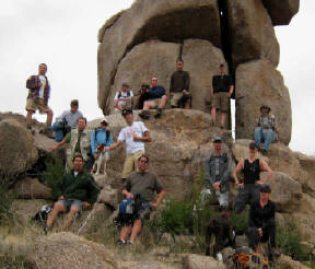
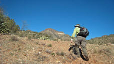
03/28/2008 Horse Trail by Cochise Head - to Indian Creek - Coronado National Forest - Chiricahua Wilderness - Chiricahua National Monument Arizona
Cochise Head, in the Chiricahua National Monument of SouthEastern Arizona - starts out our tour of a truly amazing area known as a "sky island" which supports 4 ecosystems, with spiraling pinnacle rocks reminiscent of the rock Hoodoos found in Bryce Canyon Utah. Go Virtual Hike with us as we warm up with an 8 mile stroll of Horse trail to Indian Creek, which doesn't even elude to
the *wow* yet to come. (photos by Nunya)
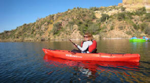
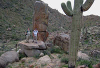
03/23/2008 Kayaking - Saguaro Lake - Tonto National Forest -
Superstition Wilderness Arizona
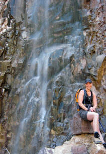
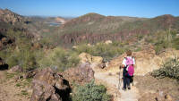
03/22/2008 Reavis Falls via Reavis Ranch Trail - Tonto National Forest -
Superstition Wildnerness Arizona
Reavis Falls, located in the Superstition Mountains of Arizona, is between 140 to 196 feet (reports vary) of shimmering glory *IF* you can time it just right. Go Virtual Hike with us 14+ miles through cascades of flowers and dozens of mini-waterfalls, with an aggressive 3169 ft of accumulative elevation gain, before an even more aggressive boulder climbing adventure - to absolutely Perfect Timing! (photos by Nunya)
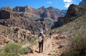
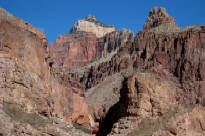
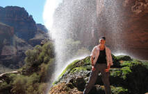
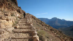
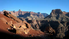
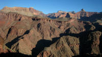
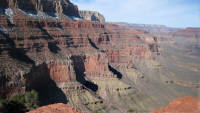
03/10/2008 South Kaibab via Phantom Ranch - Grand Canyon Arizona
Just when you thought you couldn't be shown anything new... the adventure begins all over again! Go Virtual Hike with us from Phantom Ranch, up South Kaibab. View the changes along the Colorado River from the recent Glen Canyon Dam water-release experiment, and the stunning views as you climb 4,860ft up to the ice covered South Rim of the Grand Canyon. (photos by Nunya)
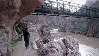
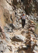
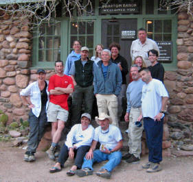
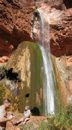
03/09/2008 Phantom Ranch - to Ribbon Falls - to Cottonwood -
to the Pump House Bridge - and Back ! - Grand Canyon Arizona
Can it get any better than this? - Absolutely! Go Virtual Hike with us from Phantom Ranch as we show you the avalanche damaged 3rd bridge to Ribbon Falls, and the major efforts the trail maintenance crew puts forth to keep the trails passable all the way through Cottonwood to the Pump Station Bridge and back! (photos by Nunya)
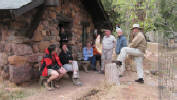
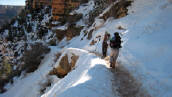
03/08/2008 Phantom Ranch via Bright Angel -
Grand Canyon Arizona
Usually.... I stick to documenting "just the trails" - but not this time! Go Virtual Hike with us 9.6 miles down Bright Angel trail (6900ft elevation) to Phantom Ranch (2400ft elevation) - sliding 2 1/2 miles down icy trail into the stunning beauty of the Grand Canyon - but THIS time... to a few of the secrets of Phantom Ranch, and the man responsible for many of us having the privilege of feeling we are coming home. (photos by Nunya)
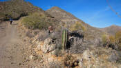
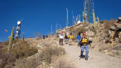
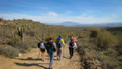
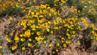
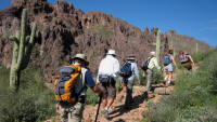
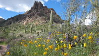
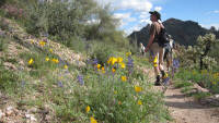
03/02/2008 Bluff Spring - Miners Needle Loop -
Tonto National Forest - Superstition Wilderness Arizona
Springtime in Arizona turns the desert into an array of absolute Eye Candy!! Go Virtual Hike with us 9+ miles around the Bluff Springs - Miners Needle Loop (est 1400ft elevation change) where a dusting of flowers turns into a Grande Finale of blooming beauty! (photos by Nunya)
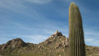
02/24/2008 Ballantine Trail via Pine Creek Loop -
Tonto National Forest - Four Peaks Wilderness - Mazatzal Mountains Arizona
Ballantine trail is an amazing display of rocks and boulders that will remind you of Stonehenge in some spots - and a fossilized dinosaur litter box in others! *hey - i call it as i see it* Go Virtual Hike with us 7+ miles (1400+ft elevation gain) on this dog friendly, hiker-happy trail, starting at the Pine Creek Loop trailhead located 8 miles South of Sunflower Arizona. (photos by Nunya)
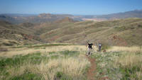
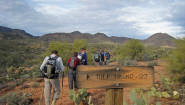
02/09/2008 Lower Two Bar Ridge Trail to Tule Trail - Tonto National Forest -
Superstition Wilderness - East Superstition Mountains Arizona
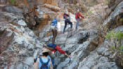
While the Tule/Upper Two Bar Ridge trail is a good trail for conditioned hikers - the Lower Two Bar Ridge Trail is NOT. Experienced Hikers only! Go Virtual Hike with us 18+ miles starting from the Campaign trailhead deep within the East Superstition Mountains, across Reavis Gap Trail, up and down Lower Two Bar Ridge to the Tule junction and back - for a rigorous hike across flowing creekbeds, overgrown to barely-there trails, and a HEFTY accumulative elevation change of 6,385ft!! (photos by Nunya)
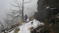
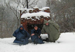
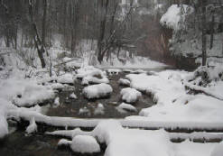
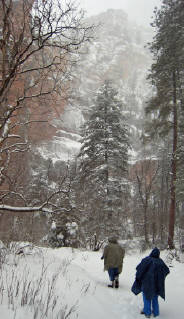
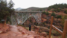
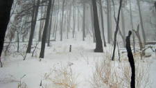
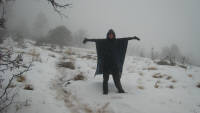
02/03/2008 West Fork Oak Creek
in the Snow
Coconino National Forest -
Red Rock / Secret Mountain Wilderness - Sedona Arizona
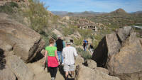
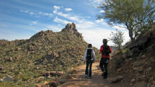
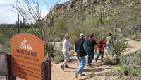
01/26/2008 Pinnacle Peak - Pinnacle Peak Park -
Scottsdale Arizona
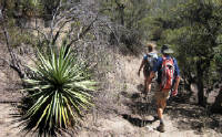
Pinnacle Peak in Scottsdale Arizona, is a mild 3+ mile local hike with panoramic views of River Mesa, Granite Mt, Four Peaks, Boulder Pass, Black Mt, Estrella Mt, Camelback Mt, McDowell Mt - and of course Pinnacle Peak! Go Virtual Hike with us on this well traveled in-and-out trail where rock climbers also go to dangle from perfectly good rocks. (photos by Nunya)
01/01/2008 Thompson Peak - McDowell Mountains -
McDowell Sonoran Preserve - Fountain Hills Arizona
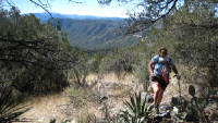
Are you looking for a hike with a warm-up, aggressive middle - then cool down? Thompson Peak in Fountain Hills Arizona is the hike for you! Go Virtual Hike with us 8.2 miles to Thompson Peak - enjoy desert landscape - 1000 year old petroglyph rock art - mine shafts constructed in the 1800's - and a 2100ft elevation climb to Thompson Peak - at 3980ft elevation! (photos by Nunya)
HIKING - BACKPACKING - CAMPING - SNORKELING - SCUBA - KAYAK -TRAVEL
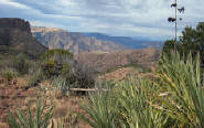
01/05/2008 Tule Trail to Upper Two Bar Ridge Trail
Tonto National Forest - Superstition Wilderness -
East Superstition Mountains Arizona
Tule Trail to Upper Two Bar Ridge Trail in the FAR East Superstition Mountains of Arizona, offers a wonderful opportunity for conditioned hikers to stretch their normal range. Go Virtual Hike with us 14+ miles of rolling hills and heart pumping elevation changes, with beautiful scenic views of Four Peaks and Apache Lake. (photos by Nunya)
01/13/2008 Bluff Springs - Miners Needle Loop - Tonto National Forest
Superstition Wilderness Arizona
01/27/2008 Wilson Mountain in the Snow -
Coconino National Forest -
Red Rock / Secret Mountain Wilderness Sedona Arizona
THIS
site was created for the disabled and busy folks
who may never have the chance to see these places otherwise,
as well as for those that do hike and want ideas of where to go.
www.GoVirtualHike.com is a site for everyone
HIKING albums are listed in date order - with the most current date at the top. The time of year, weather conditions, and people on the hike, make each album very unique. Pick a location... VIEW a slideshow - and reading the captions will transport you to that place and moment in time.
PICK A HIKE BY SEASON - JANUARY - MARCH 2008
The Superbowl had come to Phoenix, and many people were sick with the flu. The weather forecast in Sedona called for rain - but Magic is what got delivered! Go Virtual Hike with us to West Fork Oak Creek in Sedona, as snow drifted down like diamonds, huge icicles clung to Red Rock - and the snowballs flew through the air! (photos by Nunya)


FOR A LARGER VIEW
CLICK ON THE
BIGGER PHOTO
THEN SELECT
THE SLIDESHOW
OPTION TO YOUR
UPPER LEFT -
AND YOU CAN
CONTROL THE SPEED
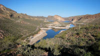
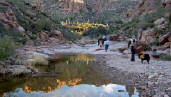
01/21/2008 Boulder Canyon Trail - Lower La Barge - Superstition Mountain Wilderness - Tonto National Forest Arizona
Go Virtual Hike with us for some highlights around the Canyon Lake, Boulder Canyo trail, and Lower La Barge area, which takes you into the Superstition Wilderness of Arizona, and the Tonto National Forest. Reflect on the beauty of the day, as we remember the life and trails shared with hiking friend Lyman Scott. (photos by Nunya)
IF YOU EXPERIENCE VIEWING PROBLEMS - disable your pop-up blocker -
CLEAR YOUR INTERNET COOKIES/TEMP FILES - THEN REFRESH YOUR BROWSER
*initial blurry photos should resize to your system within a few seconds*
Over 300
Virtual Hikes
for
HIKING
CAMPING
BACKPACKING
Over 300
Virtual Hikes
for
HIKING
CAMPING
BACKPACKING


HIKING
CAMPING
BACKPACKING
GoVirtualHike.com
GoVirtualHike.com

GoVirtualHike.com
Over 300
Virtual Hikes
for
ARIZONA
CALIFORNIA
COLORADO
HAWAII
KAUA'I
NEW MEXICO
OREGON
ST MAARTEN
UTAH
GoVirtualHike.com
Virtual Hiking
HIKING
CAMPING
BACKPACKING
GoVirtualHike.com
RESEARCH HIKES
VIRTUAL TRAVEL
VACATION GETAWAYS
Over 300
Virtual Hikes
for
ARIZONA
CALIFORNIA
COLORADO
HAWAII
KAUA'I
NEW MEXICO
OREGON
ST MAARTEN
UTAH
Virtual Hiking
GoVirtualHike.com
HIKING
CAMPING
BACKPACKING
GoVirtualHike.com
RESEARCH HIKES
VIRTUAL TRAVEL
VACATION GETAWAYS
GoVirtualHike.com
Virtual Hiking
Over 300
Virtual Hikes
for
ARIZONA
CALIFORNIA
COLORADO
HAWAII
KAUA'I
NEW MEXICO
OREGON
ST MAARTEN
UTAH
GoVirtualHike.com
HIKING
CAMPING
BACKPACKING
Virtual Hiking
GoVirtualHike.com
RESEARCH HIKES
VIRTUAL TRAVEL
VACATION GETAWAYS
GoVirtualHike.com
Over 300
Virtual Hikes
for
ARIZONA
CALIFORNIA
COLORADO
HAWAII
KAUA'I
NEW MEXICO
OREGON
ST MAARTEN
UTAH
Virtual Hiking
GoVirtualHike.com
HIKING
CAMPING
BACKPACKING
GoVirtualHike.com
RESEARCH HIKES
VIRTUAL TRAVEL
VACATION GETAWAYS
GoVirtualHike.com
Virtual Hiking
Over 300
Virtual Hikes
for
ARIZONA
CALIFORNIA
COLORADO
HAWAII
KAUA'I
NEW MEXICO
OREGON
ST MAARTEN
UTAH
GoVirtualHike.com
HIKING
CAMPING
BACKPACKING
GoVirtualHike.com
RESEARCH HIKES
VIRTUAL TRAVEL
VACATION GETAWAYS
Virtual Hiking
Over 300
Virtual Hikes
for
ARIZONA
CALIFORNIA
COLORADO
HAWAII
KAUA'I
NEW MEXICO
OREGON
ST MAARTEN
UTAH
GoVirtualHike.com
Virtual Hiking
HIKING
CAMPING
BACKPACKING
GoVirtualHike.com
RESEARCH HIKES
VIRTUAL TRAVEL
VACATION GETAWAYS
GoVirtualHike.com
Over 300
Virtual Hikes
for
ARIZONA
CALIFORNIA
COLORADO
HAWAII
KAUA'I
NEW MEXICO
OREGON
ST MAARTEN
UTAH
GoVirtualHike.com
HIKING
CAMPING
BACKPACKING
GoVirtualHike.com
RESEARCH HIKES
VIRTUAL TRAVEL
VACATION GETAWAYS
GoVirtualHike.com
Virtual Hiking
Over 300
Virtual Hikes
for
ARIZONA
CALIFORNIA
COLORADO
HAWAII
KAUA'I
NEW MEXICO
OREGON
ST MAARTEN
UTAH
GoVirtualHike.com
HIKING
CAMPING
BACKPACKING
GoVirtualHike.com
RESEARCH HIKES
VIRTUAL TRAVEL
VACATION GETAWAYS
GoVirtualHike.com
Over 300
Virtual Hikes
for
ARIZONA
CALIFORNIA
COLORADO
HAWAII
KAUA'I
NEW MEXICO
OREGON
ST MAARTEN
UTAH
GoVirtualHike.com
HIKING
CAMPING
BACKPACKING
Over 300
Virtual Hikes
for
HIKING
CAMPING
BACKPACKING
GoVirtualHike.com
RESEARCH HIKES
VIRTUAL TRAVEL
VACATION GETAWAYS
GoVirtualHike.com
Over 300
Virtual Hikes
for
ARIZONA
CALIFORNIA
COLORADO
HAWAII
KAUA'I
NEW MEXICO
OREGON
ST MAARTEN
UTAH
GoVirtualHike.com
HIKING
CAMPING
BACKPACKING
TRAIL AREAS DOCUMENTED ON THIS PAGE
FIND IT FAST!
Hit Control F
Type your Keyword
Jump to the hike you're looking for Fast!


I AM AWARE THAT KODAK HAS MADE CHANGES TO THEIR SOFTWARE - THAT NOW SCREW UP YOUR VIEWING THOSE SLIDESHOWS - I'LL FIX THOSE AS SOON AS I CAN *SORRY*
I AM AWARE THAT KODAK HAS MADE CHANGES TO THEIR SOFTWARE - THAT NOW SCREW UP YOUR VIEWING THOSE SLIDESHOWS - I'LL FIX THOSE AS SOON AS I CAN *SORRY*
I AM AWARE THAT KODAK HAS MADE CHANGES TO THEIR SOFTWARE - THAT NOW SCREW UP YOUR VIEWING THOSE SLIDESHOWS - I'LL FIX THOSE AS SOON AS I CAN *SORRY*
I AM AWARE THAT KODAK HAS MADE CHANGES TO THEIR SOFTWARE - THAT NOW SCREW UP YOUR VIEWING THOSE SLIDESHOWS - I'LL FIX THOSE AS SOON AS I CAN *SORRY*
I AM AWARE THAT KODAK HAS MADE CHANGES TO THEIR SOFTWARE - THAT NOW SCREW UP YOUR VIEWING THOSE SLIDESHOWS - I'LL FIX THOSE AS SOON AS I CAN *SORRY*
I AM AWARE THAT KODAK HAS MADE CHANGES TO THEIR SOFTWARE - THAT NOW SCREW UP YOUR VIEWING THOSE SLIDESHOWS - I'LL FIX THOSE AS SOON AS I CAN *SORRY*
I AM AWARE THAT KODAK HAS MADE CHANGES TO THEIR SOFTWARE - THAT NOW SCREW UP YOUR VIEWING THOSE SLIDESHOWS - I'LL FIX THOSE AS SOON AS I CAN *SORRY*
I AM AWARE THAT KODAK HAS MADE CHANGES TO THEIR SOFTWARE - THAT NOW SCREW UP YOUR VIEWING THOSE SLIDESHOWS - I'LL FIX THOSE AS SOON AS I CAN *SORRY*
I AM AWARE THAT KODAK HAS MADE CHANGES TO THEIR SOFTWARE - THAT NOW SCREW UP YOUR VIEWING THOSE SLIDESHOWS - I'LL FIX THOSE AS SOON AS I CAN *SORRY*
I AM AWARE THAT KODAK HAS MADE CHANGES TO THEIR SOFTWARE - THAT NOW SCREW UP YOUR VIEWING THOSE SLIDESHOWS - I'LL FIX THOSE AS SOON AS I CAN *SORRY*
I AM AWARE THAT KODAK HAS MADE CHANGES TO THEIR SOFTWARE - THAT NOW SCREW UP YOUR VIEWING THOSE SLIDESHOWS - I'LL FIX THOSE AS SOON AS I CAN *SORRY*
I AM AWARE THAT KODAK HAS MADE CHANGES TO THEIR SOFTWARE - THAT NOW SCREW UP YOUR VIEWING THOSE SLIDESHOWS - I'LL FIX THOSE AS SOON AS I CAN *SORRY*
I AM AWARE THAT KODAK HAS MADE CHANGES TO THEIR SOFTWARE - THAT NOW SCREW UP YOUR VIEWING THOSE SLIDESHOWS - I'LL FIX THOSE AS SOON AS I CAN *SORRY*
I AM AWARE THAT KODAK HAS MADE CHANGES TO THEIR SOFTWARE - THAT NOW SCREW UP YOUR VIEWING THOSE SLIDESHOWS - I'LL FIX THOSE AS SOON AS I CAN *SORRY*
I AM AWARE THAT KODAK HAS MADE CHANGES TO THEIR SOFTWARE - THAT NOW SCREW UP YOUR VIEWING THOSE SLIDESHOWS - I'LL FIX THOSE AS SOON AS I CAN *SORRY*